![]()
|
We knew this chase day was coming 3 days beforehand. Simon, Tom and I were staring at the SPC's Day 1 outlook at 1am that morning, waiting for them to upgrade to High Risk. Of course, it was upgraded to High Risk at about 1:30 a.m. We decided to head to a town east of Dodge City, a town called Kinsley. Ironically, that is one of our friends home town. At any rate, we left Norman at 6:30am, with full intentions on skipping all of our class. After all, there was a high risk for damaging tornadoes, not something that happens every day. We made it to Kinsley at noon, just as the first storm had gone up. But, there was one slight problem, it was overcast, and we couldn't see anything. The only reason we knew about this storm that was just east of Garden City, KS, was because we called our friend Eric. To make a long story short, we got screwed over. Nothing really happened, the cloud cover inhibited convection, and a squall line formed in the Texas/Oklahoma panhandles and western Kansas. So, I guess this technically wasn't a bust, but for all practical reasons, it WAS! |
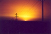
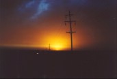
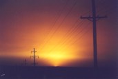
Here are some sunset pictures taken in the Oklahoma Panhandle behind the dryline.
 |
 |
 |
Home | Storm Store | Photo Gallery | Message Board | Storm Chases | Latest News
Stock Footage | About | Contact | Editorial | Weather Links
Copyright 2001 Stormgasm.com. All rights reserved.