![]()
Sample
Clip 0:31
min 5mb
|
On May 8, 2003 Simon Brewer was in his Astro Minivan taking on the large F-4 wedge tornado that ripped through the General Motors (GM) Plant in Oklahoma City (OKC). Similar to May 3, 1999, the tornado tracked through the northern side of Moore, Oklahoma. Well, Jim Bishop came over early and I gave him my video camera, so he and Mark McGowen could maybe get some decent video up in Kansas. I hadn't looked at anything since the night before and thought it looked incredible in Kansas, but I had a final exam in Dynamics the next morning. I made the decision to not chase and pass my class. After Jim left I went back to sleep and woke up later in the morning to study. I'm a huge weather nut, so before opening the books I checked the weather conditions; I was blown away! The 12z sounding looked like the CAP might break in central OK with high CAPE and amazing shear. I flipped out, because I didn't have a video camera; I let Jim borrow it! I may have beat the temptation to chase in Kansas, but when it looks like a violent tornado may develop within 100 miles of my home I just can't hold back the tide. Lucky for me my roommate Jarod had an old High 8 Cannon video camera, but I had to wait to charge the battery. Even with the battery fully charged Jarod told me I had maybe 15 minutes before it went dead, but 15 minutes of video is better than no video. By late afternoon satellite imagery showed cumulus towers pulsating near Chicasha, OK. Echo tops on radar showed one tower rise to 35 thousand feet; the video camera had just finished charging, so I ran out the door and hauled it north on I-35 for Guthrie, OK. There were some serious wild fires in Mexico this year, so the strong southerly flow associated with this shortwave brought some of the smoke northward causing very hazy conditions when mixed with deep moisture. I could hardly see anything, definitly not any cumulus towers, so I needed data; when I got to Guthrie I drove into town and made a stop at the public library. I quickly looked at radar and satellite and saw the original towers died and a new cluster of towers and one with a small reflectivity core had developed over Chicasha. I waited another couple of radar frames to see if this new development would hold and to see the direction of movement. When the new cell showed rapid strenghening and movement to the northeast in the direction of southern OKC and Moore I knew that was the storm and it was time to haul it south. A medical student from Tulsa was at the computer next to me; he told me he was an ametuer storm chaser. I told him he needs to go south after this rapidly developing cell and he said he would wait for something further north. I told him good luck and left; maybe he got on the Osage County storm later in the evening. Well, I gunned it south and in minutes I was passing though OKC with a massive storm to my SSW blocking the sun. I could see a definite left split from the main cell and it dropped some rain on me on the northwest side of OKC. I had the radio on and Rick Mitchel from channel 9 was giving live commentary telling people not to worry, because a tornado has not been spotted, but then he said something I will never forget, "...I can't believe it, a large tornado has been spotted in Moore producing damage. I can't believe this is happening..." at least what he said was along those lines. They were getting reports from spotters the tornado was about to cross I-35, so I turned onto I-40 to get east of the tornado. Just north of Tinker Airforce Base I hit stand-still traffic and baseball-sized hail began pounding my van. I thought for a moment I would get hit on I-40 in a traffic jam by a major tornado, but my exit slowly arrived and I drove south on Douglas Blvd. east of Tinker Air Force Base. I couldn't see very far to the west, but I could see a bunch of debris, which was lofted high into the air to my west. Also, there was an incredibly low and fast moving (to the west) beaver's tail feeding into the storm over the road. |
|
|
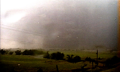
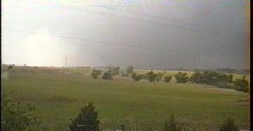
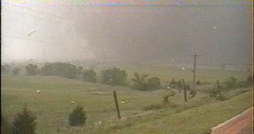
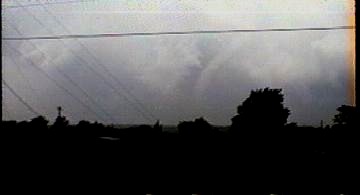
I turned onto a service road paralleling I-240 on the south side of Tinker Air Force base and headed west. When I crested a hill I could see the tornado, tornado-cyclone, and RFD clear-slot. I decided a tornado was in view, so I turned the video camera on and began recording. The pic on the right is a video still looking WSW at the tornado, the side of the tornado cyclone can be seen and the bright area on the right is the RFD clear-slot. I was actually in the left turn lane for South Midwest Blvd. I sat in the left turn lane for a few seconds looking at the map and then at the tornado to see determine where I should stop and tape the tornado; it appeared the tornado was heading very close to my location, so I decided to turn south on S.Midwest Blvd, crossed the I-240 bridge and parked the van on the south end of the bridge with two tires over the curb and two tires on the shoulder. Interesting to note: after the tornado passed me by I drove back to this service road and there was a large chunk of a wooden power telephone pole almost the size of my van sitting in the left turn lane where I was located just after this video still on the right. |
 |
|
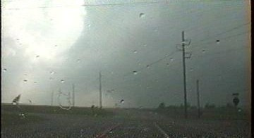
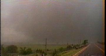
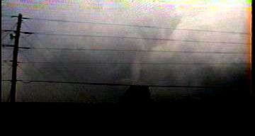
The pic on the right is a video still looking WSW at the approaching stove-pipe tornado as I was heading south on S.Midwest Blvd. |
 |
|
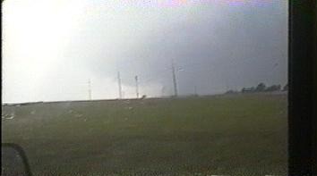
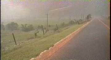
The pic on the right is looking WSW at the approaching tornado and I-240 as I was parking on the south side of the bridge crossing I-240 on S.Midwest Blvd. |
 |
|
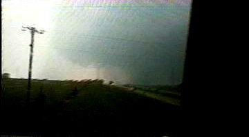
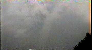
I jumped out of the van and began video taping the tornado; it appeared to be transitioning between a large stove pipe and a small wedge in shape. It was hazy and there was an incredible amount of debris associated with this tornado making it difficult to discern the condensation funnel, especially on video. The pic on the left is a video still looking almost due west at the approaching tornado; I was certain at this point it would pass very close to me, but north of my location; directly over the General Motors Plant and Tinker Air Force Base. Can't make out the condensation funnel in this pic, because there is too much debris and some rain wrapping around the large tornado, but that dark mass is the tornadic circulation; about 1/2 mile wide. |
 |
|
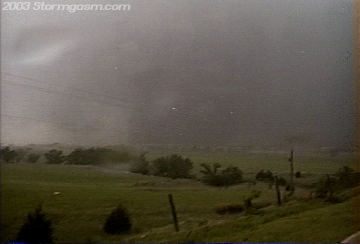
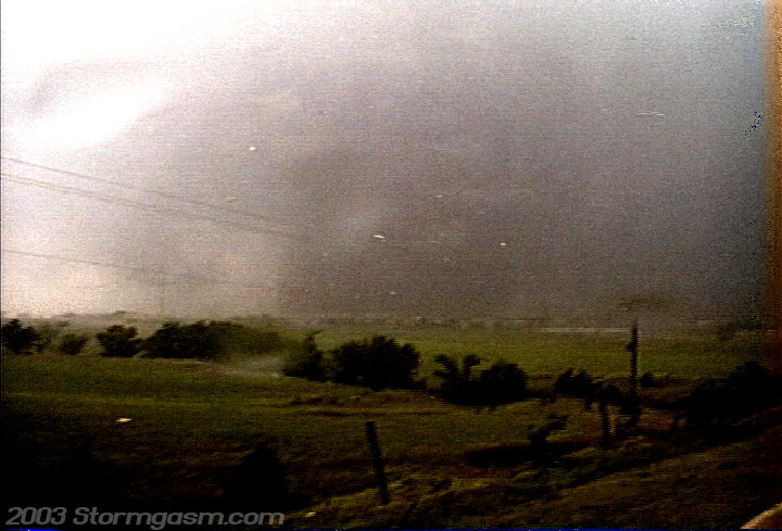
The pics on the right and left are the same video stills, but I enhanced the contrast on the still on the right to see the dark, debris-filled, violent, wedge/large stovepipe-shaped tornado vortex. The tornado was doing F4 damage to the GM Plant at this point and is about 200 meters from my location. The still is looking NW at the tornado. The 'white stuff' in the image is insolation from houses that had been destroyed in Moore. Lots of debris was flying by me at this point; I was using my van to shelter me from the strong RFD winds, but my van was significantly rocking from side-to-side. |
 |
 |
|
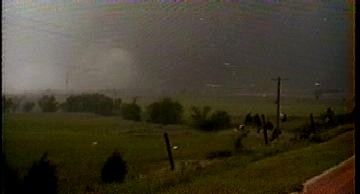
The pic on the right is a video still looking NNW at the tornado as it moves closer to my location, but to the north. I'm so close to the tornado that I'm almost in the debris field, well, debris is flying all around my, but I was not in the debris field yet... |
 |
|
I had never seen so much debris inside a tornado; the pic on the right is a video still looking NNW at the wedge tornado doing serious damage to the GM Plant and Tinker Air Force Base. I'm on the edge of the debris field now and the dark condensation/debris vortex can be seen pretty well. I was on a higher elevation on the south end of this bridge and the winds were incredibly strong. My van was rocking so much that I was now worried it would roll onto me and crush me; I was actually getting hit by my van pretty hard as it rocked from side to side. |
 |
|
The pic on the right is looking due north along S.Midwest Blvd at the F4 wedge tornado as it is over the GM Plant and Tinker Air Force Base with the south side of the vortex about 150 meters from my location. I was pretty sure the van was about to tip over at this point, so I slowly began to back away from the van. As I did this I looked directly above me and I could see the slope of the wedge tornado as it met with the base of the tornado cyclone directly over my head; this was, absolutely, one of the most amazing things I've ever witnessed! I was deep in the debris field at this point, but my instinct told me to get the hell away from that van before it rolled and crushed me, so I ran south. I hit an incredible wind that almost knocked me off my feet, literally, when I left the wind shelter of my van. My sunglasses and hat instantaneously lifted off me and were carried up and away to the northeast. I have been in winds similiar to this strength since this time in hurricanes, but that wind field was more horrizontal and would have definitely knocked me down, but this wind had a vertical component to it that felt like it was pushing me sideways and trying to lift me upwards; could have been an effect caused by my higher local elevation near the edge of the bridge, but my sunglasses and hat were now somewhere in east of Tinker. I was pelted by all sorts of debris from pieces of insulation, hard and painful black roofing material, some chunks of wood, tree branches, and even hail. After 'running' about 30 or 50 meters south of my van I saw an SUV with people hanging out the window waving for me, so I made an easy decision to join them in their vehicle instead of being pelted by debris until the tornado moved away. It ended up being a Mexican-American family that was very kind and saw me and thought I needed some help. I was thankful and they drove me back to my, surprisingly still in one piece, van. Apperently it did not tip over after all, but that was okay, because I jumped behind the wheel, thanked the family, and continued to chase after the violent tornado as it move through Midwest City. |
 |
|
The pic on the right is a video still looking due north along S.Midwest Blvd right before I began running south to avoid possible dissaster with my van if it were to roll onto me. Spray can me seen as water is blown off and over the road surface, and a big piece of debris swiftly crossed in front of the camera, which can be seen as that white streak on the top center of the vid still. I think that chunk of debris is insolation, but notice the horizontal and vertical direction it was moving, which is the movement my sunglasses and hat took as they got pulled off me shortly after this video still. |
 |
|
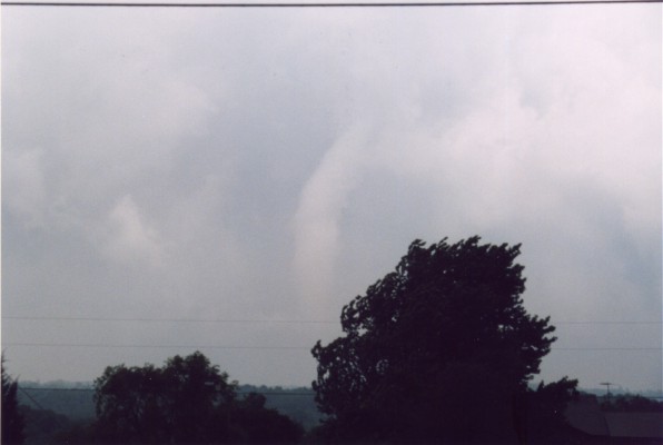
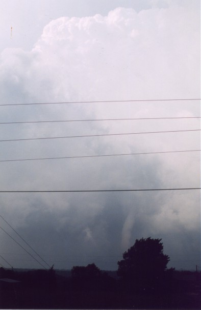
I drove east along the service road (actually it's called SE 74th St.) and I'm a little foggy on the actual streets I took, but I believe I turned north on Post Rd, then turned east on SE 59th and ended up somewhere near and north of the intersection of I-40 and I-240 south of Choctaw. The pic on the right is a video still looking north at the tornado as it was roping-out over Choctaw, OK. The tornado was still causing F3 and F4 damage as a rope in the Choctaw area. |
 |
|
The pic on the right is a video still looking north at the tornado as it was roping-out over Choctaw, OK. I had a friend who lived in Choctaw and said the tornado passed very close to his home, and luckily his property received no damage. |
 |
|
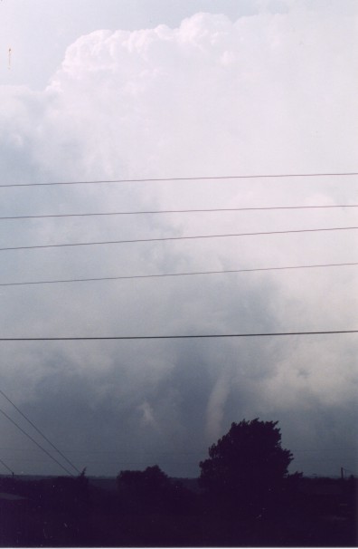
The still on the left is looking north at a section of the rope tornado over Choctaw, OK; I zoomed in on the tornado, but it was hazy and the camera was low quality. The video still on the right is looking north toward Choctaw and much of the mesocyclone and tornado cyclone structure can be seen around the tornado. |
 |
 |
|
The pic on the right is actually a photograph I took of the tornado as it was over Choctaw. This was a large fat rope and it was doing F4 and F3 damage! |
 |
|
The pics on the right are photographs looking north at the tornado over Choctaw and show some of the updraft structure above the tornado. Interesting to note the tornado dissapated soon after these pics were taken, and the storm was being cut off from surface-based moist air by the strong CAP, but the NWS in Norman still had a tornado warning for the storm, because so much debris had been lofted into the air by this large tornado that the water covered debris was showing up on radar as a hook or 'debris ball', so the NWS employees thought there was still a tornado on the ground, but the storm was ending. |
 |
 |
|
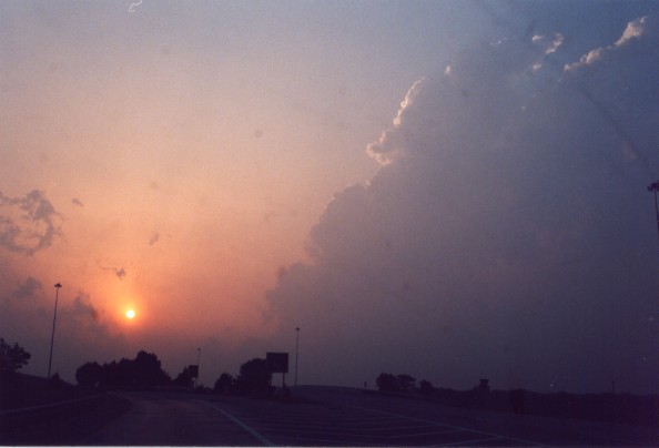
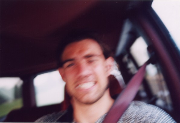
The photo on the left is looking WNW on I-44 at the sun setting behind a large updraft tower that never made it much further east off the dryline before being cut-off from the CAP. I was heading back to OKC to feed my video to Channel 4, CNN, ABC News and Good Morning America. The pic on the right is a self portrait photo, while driving and I was happy with my day, even though I would fail my dynamics final the following day due to not studying on this day. I look back on this day as a good day for me, but a very bad day for all the poor victims, humans and animals, that suffered due to this destructive weather event. It is very hard to enjoy something that causes so much grief for others, but then again, this weather event would have occured regardless of the people and places in its path. People ask me sometimes how I can enjoy something so bad for other people and I can only respond in this way: "I don't enjoy the destruction, I appreciate and enjoy watching incredible dynamical displays of nature, it is merely a sad consequence that sometimes human civilization is negatively affected." |
 |
 |
Home
| Storm Store | Photo
Gallery | Message
Board | Storm Chases | Latest
News
Stock Footage | About
| Contact | Editorial
| Weather Links
Copyright 2004 Stormgasm.com. All rights reserved.