Western Trip 2008
September 24th - October 7th
|
Anna and I kinda planned this trip, if you could call it a plan, since late spring of 2008, but we really didn't know what it was going to be until two weeks before it had begun. In the late spring of 2008 Anna and I had successfully completed our respective degrees at the University of Oklahoma and wanted to, "take a trip out West", as Anna had said in the infancy of our plans. Anna originally wanted to be out roaming the 'West' for at least a month, but I knew that was not going to happen, because bills aren't going to pay themselves, so I thought about two weeks was good. Also, we originally kinda planned to begin our journey in August and see the entire 'West', which included the Northwestern and Southwestern United States, but August was prime 'Hurricane Season' and two weeks was not enough time to travel that much territory and still have time to exit the car and walk a few steps. So, since we took a small trip to Idaho and Wyoming in early August we decided to focus on the Southwestern U.S. and back the trip up into late September/early October to catch the last days of the summer ridge and yet avoid the blistering heat of mid-summer. Everything worked out pretty well and we visited the following major points of interest in order: climbed Humphrey's Peak, AZ, Grand Canyon National Park, AZ, Glenn Canyon Dam, AZ, Zion National Park, UT, Extraterrestrial Highway, NV, drove by Boundary Peak, NV, Devils Postpile National Monument, CA, Yosemite National Park, CA, drove through Sacremento Valley, CA, Lassen Volcanic National Park, CA, Redding, CA, Redwood National/State Parks, CA, drove to Oregon/California border, drove over Golden Gate Bridge and through San Francisco, CA, Kings Canyon National Park, CA, Sequoia National Monument/National Park, CA, Mojave Dessert, CA and AZ, Sunset Crater National Monument, AZ, and finally Petrified Forrest National Park, AZ. We had the privilage to climb the highest mountain in Arizona, see amazing canyons, hike to awesome waterfalls, drive across vast deserts, walk amongst the tallest, largest, and some of the oldest living organisms on earth, witness seals playing in the crashing waves of the Pacific ocean, drive across national landmarks, and touch ancient forrests now turned to stone. It was an unforgettable trip that I would love to do again. Luckily our trip was positively affected by the significant drop in fuel prices, but sadly we had to listen to the major financial crisis over NPR during the long drives in between our many destinations. Below are merely a few teaser pics of what we saw, and like always, the pictures don't do our trip justice, but I still did my best to capture the scenes as they were... |
|
Image on the right is looking at the northeastern side of the interior of the giant crater in Humphry's Peak. We were at about 12,000 feet in elevation on the west side of the crater rim when I took this picture. Humphrey's Peak is merely the highest point on the north side of the rim of this gigantic volcano in northern Arizona. |
 |
|
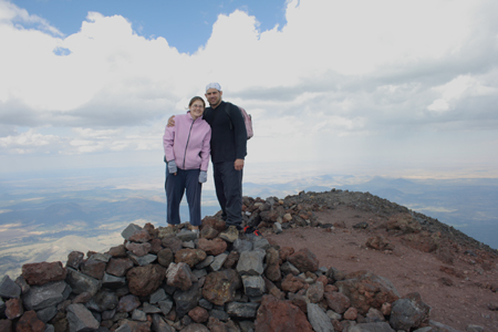
Image on the right was taken by a kind man we met on top of Humphrey's Peak. This is our 'summit picture' proof that we made it to the top: 12,633 feet, which is the highest point in the state of Arizona. It was really cool to see the entire massive volcano. |
 |
|
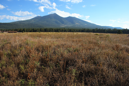
Image on the right shows the south side of Humphrey's Peak: I took this pic looking Northeast from the highway, which headed to the Grand Canyon National Park. The distant peak on the far left behind the other peaks is the highest point. The complex of peaks is actually called the San Francisco Mountains even though it is one giant volcano with seperate peaks along the huge rim. |
 |
|
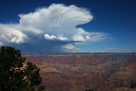
Image on the right shows our first view of the Grand Canyon! Pic is looking north-northwest at a thunderstorm, which had developed over the North Rim of the canyon. Everyone we had spoken to before we had arrived at the Grand Canyon recommended going to the North Rim, but we had decided to go there another time due to time restraints, because we wanted to continue to Zion National Park the next day. |
 |
|
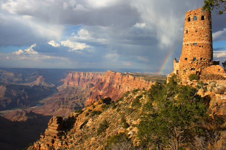
Image on the right shows the historic Desert View Watchtower on the South Rim of the Grand Canyon National Park with a rainbow in the background. We were lucky, because a thunderstorm had moved over the right area with a very skinny rainshaft at the right time to get this shot. |
 |
|
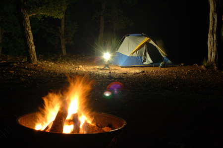
Image on the right shows our campsite at the Grand Canyon National Park: fire, lantern, tent, and beautiful scenery. |
 |
|
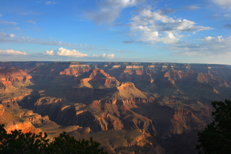
Image on the right shows our last views of the Grand Canyon National Park as the sun rose the following morning; absolutely gorgeous! |
 |
|
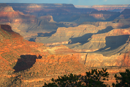
Another sunrise pic, the depth of the canyon was amazing! |
 |
|
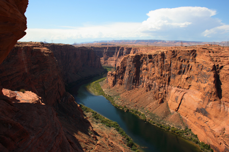
We stopped at Glenn Canyon Dam on the way to Zion National Park: it's pretty amazing and yet sad, because Glenn Canyon is amazing as seen down stream from the dam in the picture on the right, but behind my position is a dam backing up the Colorado river and clogging a huge portion of Glenn Canyon resulting in a huge ecological disaster. The dam is pretty amazing, because it is a big engineering feat, but I'm not sure what would have been better; the propper management of an incredible canyon bringing lots of tourists and associated benefits, or a big lake in the desert helping to fuel unnecessary urbanization in the desert? |
 |
|
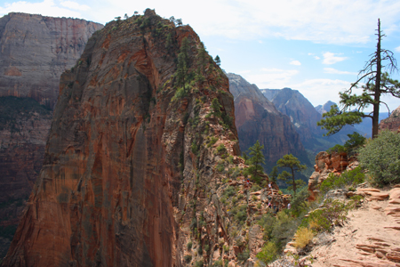
Now comes Zion National Park and all its glory! The pic on the right shows the second section of the Angel's Landing Trail at Zion National Park. We basically hiked halfway up the main canyon wall and into another smaller canyon to get to this point of the trail; now we had to walk/crawl along that very skinny rock ridge to the top of Angel's Landing. Don't do the second part if you have a big fear of heights, because there are parts where there is literally thousand foot cliffs on both sides of the trail and only one or two feet of trail room and a big metal chain to grasp for comfort. |
 |
|
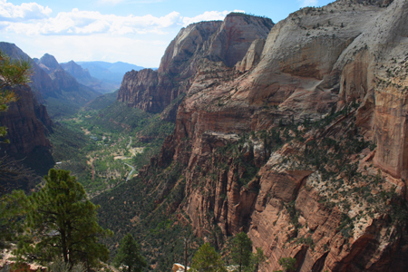
View of the main Zion Valley looking south; the main road and Virgin River winds through Valley floor more than a thousand feet below my location. |
 |
|
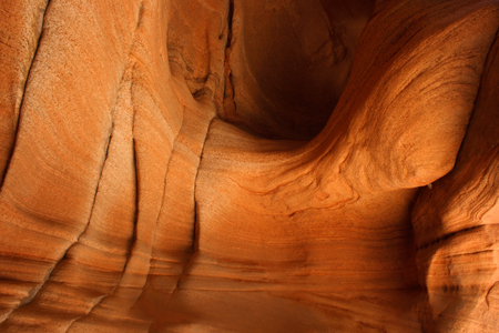
Image on the right shows a cave like feature off the edge of Refridgerator Canyon on the Angel's Landing trail; I took this photo on the way down, the 'cave' was most likely carved by rocks swirling in a wirlpool on the edge of the canyon when the creek or river level was at this location millions of years ago. |
 |
|
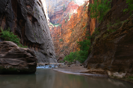
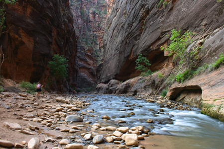
Image on the right shows another trail or lack of trail we hiked at Zion; The Narrows. This trial begins on the north end of the main Zion Valley and follows the Riverside Trail for a mile, but then you must enter the Virgin River to continue to the Narrows. The river is pretty much wall to wall at from this point onward, so we got in, Anna found a crude walking stick someone had discarded on the side of the trail and I used my fully extended camera tripod for support on the slippery stones and boulders, while wading through the ankle deep waters. It was my favorite trail that we had hiked in Zion, but Anna liked Angel's Landing the most. |
 |
|
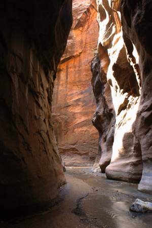
Another shot of the Narrows; it was amazing, and yet very hard to shoot, because the bottom of the canyon was dark from no sunlight reaching the water, but the upper sections of the canyon were very bright from daylight/sunlight, so I had to reach some sort of middle ground to get a decent picture. |
|
|
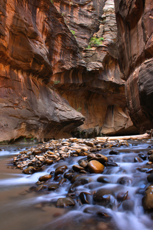
As we continued onward the canyon becomes more narrow, hence, the Narrows. We only went a couple of miles before turning around, but apparently you can follow the canyon for another 10+ miles before exiting on the high country above the canyon. But, we had more parks to see, and I would love to return to Zion and go further up the Narrows. |
 |
|
This was a small tributary that connected with the Virgin River; we ventured up this creek a few hundred yards before turning around and heading back down river. This was the most narrow section we encountered, but apparently it gets tighter, to the point that you've got to squeeze through some spots in the canyon... cool! |
 |
|
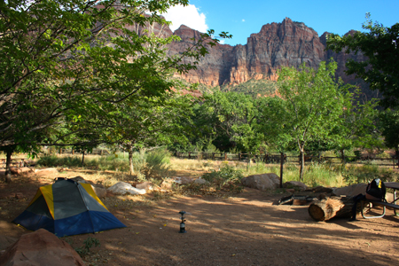
This was our campsite at Zion National Park: probably hands down the best view I've ever had at my campsite. Absolutely beautiful canyon walls from the view of our tent. |
 |
|
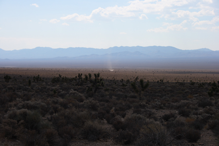
We had to cross the vast mountains and deserts of Nevada and drive the Extraterrestrial Highway to reach our next destination, Devils Postpile National Monument in California, and I must say this was some of the most desolate landscape I've ever seen. I thought Wyoming was bad, but Central Nevada might have it beat. Despite the isolation, this place had its own beauty, and we saw tons of dustdevils! The pic on the right shows just one of the hundreds of dust devils we saw driving through Nevada. |
 |
|
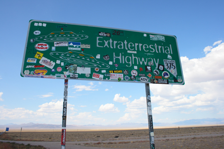
The sticker-covered sign marking the "Extraterrestrial Highway" in central Nevada. No wonder people see the most UFO sightings on this highway, because it passes just north of a huge military complex including Area 51! Lots of top secret test aircraft from the military pass have passed over this highway over the years including the newer Stealth aircraft. |
 |
|
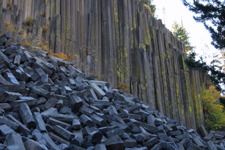
Pic on the right shows Devils Postpile at Devils Postpile National Monument on the western slopes of the Sierra Nevada Mountain Range in east central California. It was difficult to get a good shot with the backlighting behind the Postpile, because the sun was rising behind the geological feature blowing out the sky. |
 |
|
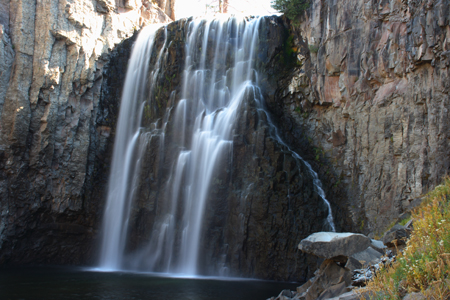
This is Rainbow Falls at Devil's Postpile National Monument. We hiked a five miles roundtrip to see this waterfall and it was definitely worth it, but we had to see the waterfall and continue back to our car and were only able to see a brief and small part of the rainbow created by the mist scattering sunlight near the falls. Apparently, during the middle of the day, like 1-2 PM, there is a decent sized rainbow visible in the mist around the falls, but we were too early for that; the sun was too low on the horizon and the falls were in mostly in shadow. |
 |
|
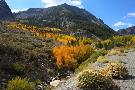
We left Devil's Postpile and continued north and then cut east across the heart of the Sierra Nevada Mountains into the east entrance of Yosemite National Park. This pic was taken at about 9-8,000 feet looking west at the western border of Yosemite National Park. The Aspen were changing to gold and the alpine scenery was awesome. The eastern gate to Yosemite was almost 10,000 feet in elevation! |
 |
|
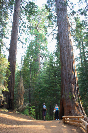
We arrived in the park around noon, and it took a good portion of the day to drive to the northwestern portion of the park where we got a campsite. By then the sun was getting low, so we took a short 2-mile-round-trip hike to see a small grove of Giant Sequoias; Tuolumne Grove. It was amazing to finally fullfill a childhood dream of seeing some Giant Sequoia Trees; the largest, by volume, trees on earth! The pictures don't really show their size, but later on our trip we would see massive coastal redwoods and the biggest of the big at Sequoia National Park. |
 |
|
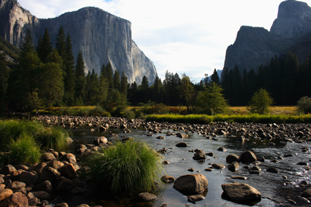
We had planned on spending 2-3 days in Yosemite National Park, but the following morning we woke up really early and drove to the most popular portion of the park; Yosemite Valley, and attempted to get a campsite, but there was on one campground out of three that did not require reservations, and that campground smashed 6 people per site whether they are from your party or not and the campsites were not big! Just getting around Yosemite Valley was a pain, and then we get to the open campground really early, like 7:30 or 8am, and there is a huge line of rock climbers waiting for sites at the permit booth. We waited for a little bit and decide to just hike around that day and then leave the park that night. Instead, we ended up circling Yosemite Valley 3-4 times looking for a place to park and then got fed up and just left the park, but did a very, very, very short hike to a waterfall on the way out. Yosemite Valley needs to learn from Zion National Park and set up the Valley in that fasion, because the way layout of that Valley was a cluster ****! We said, "screw this place", but used more colorfull language and decided to gun it up to Lassen Volcanic National Park. The pic on the right is looking at Yosemite Valley and El Capitan. |
 |
|
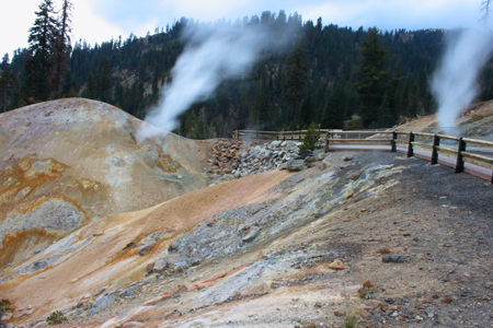
We originally did not plan on going to Lassen Volcanic National Park nor Redwood National/State Parks, but due to free time caused by quickly leaving Yosemite we decided to make the long trip north for these two jewel parks. The pic on the left shows two big steam vents on either side of the main road going through Lassen Volcanic National Park. Lassen Peak is the center piece of the park and blew its top back in the early part of last century. Until Mount Saint Helens exploded in the 1980's Lassen was the most active volcano in the Cascades. Lassen was really cool, and according to a very nice man we met in Zion National Park it is the least visited National Park, which made it a huge break from the crowds we encountered at Yosemite.
More parts of the trip will be added later, and, eventually, more pics of each point of interest will be added... |
 |
|
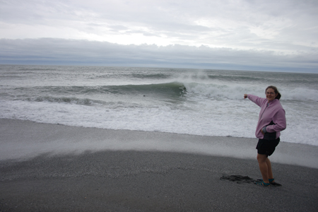
We did not leave the boundary of Lassen Volcanic National Park until after dark. The large shortwave trough had already begun to pound Northern California with rain and wind, initially caused by warm air advection precipitation aided by upslope. Lassen Peak had been shrouded in clouds and drizzle and though we had a relatively dry drive that night to Redding, CA the night sky was overcast. We stayed at one of three motels on our trip that night in Redding. We woke early the next morning to gloomy conditions; light to moderate rain and overcast skies. Also, I had been on the computer that morning and somehow caused an 'kink' in the spine on my upper back: the pain was sharp, intense, and awefull. It was not muscle pain, but might be a result of muscle affects on the spine, but it was definitely coming from the spine! I had an injury that left me on my Grandmother's couch for days back in late July before the pain subsided, so I knew I would be in horrible pain the next few days. I wasn't going to let this slow us down, so I made a makeshift neck rest-type-thing for the curvy mountain drive to the Pacific Coast. The drive was rather dangerous, because this was the first big rainfall of the season, so there were small landslides everywhere. We had to dodge rocks and debris on the curvy roads all the way to the coast, and, also, the rain was moderate to heavy all day. The pic on the right shows Anna pointing at a seal in the wave (notice the black dot in the wave, which is the seal's head). This was at the south side of Redwood National/State Park. |
 |
|
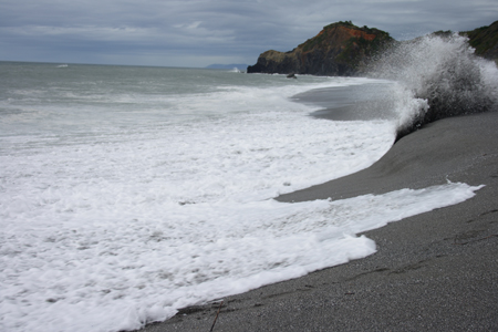
The coastal range of Califoria was beautiful and dangerous; I was actually pretty excited to experience a strong trough slamming into the west coast for the first time. This was, also, the first time Anna and I had ever seen the Pacific Ocean. Anna immediately ran to the edge of the shorline and watched the waves crash with joy, I whipped out the tripod and began taking pictures, while in serious pain. The pic above and to the right shows Anna pointing at the head of a seal in a crashing wave. Two seals were there, but only one head can be seen in the pic, and they apparently just popped up to check out the two strange humans on the beach in the horrible weather conditions. I thought at the time, and still do, that the overcast and rainy conditions were perfect, because those are the norm for this area a majority of the year. The pic on the right shows a wave crashing on the Northern California shore. Redwood National/State Park is a combination of Federal and State parks run as one. The state park actually is much older than the National Park, which is a rare occurence, and the two have interconnected borders. The park goes from the coast into the hills and mountains of the coastal range. A diverse park with bays and beaches, cliffs, hills, mountains, lots of wildlife, and the tallest trees in the world; the coastal redwoods. |
 |
|
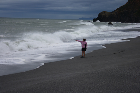
I'm not sure what Anna was pointing at in the picture on the right, but the waves crashing around her look amazing! |
 |
|
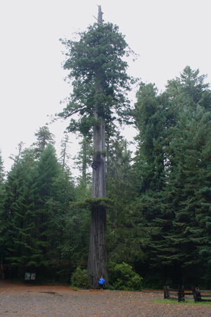
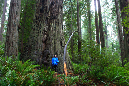
We didn't have much time in the park since we spent most of the day driving from Redding, so we hit the closest tall tree grove with a mile and a half loop trail, which happened to be a small grove on the south end of the park called 'Lady Bird Johnson Grove'. The tallest trees were not in this grove, but they were huge nonetheless. The pic on the right shows Anna (blue poncho) standing in front of a very tall tree in the parking lot for the Lady Bird Johnson Grove. The coastal Redwoods (a sequoia tree, but different species than the Giant Sequoia) have a greyish-brown bark unlike the reddish brown, almost glowing, bark of the giant sequoias we had seen at Yosemite and again later in the trip at Sequoia National Park. The trees were still beautiful and majestic. |
 |
|
It was very difficult to get decent pictures due to the constant rain and I was not taking as many shots due to the insane pain in my upper back. The pic on the right shows moss draping over trees in the foreground and the trunks of large redwoods in the back ground. |
 |
|
Pic on the right shows Anna posing in front of a very large redwood. |
 |
|
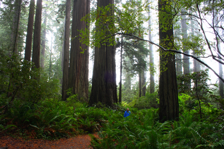
I can't explain on this webpage how incredible it was at that park; I wish we could have spent more time there. The pic on the right shows Anna (blue poncho) surrounded by huge ferns and giant redwoods, which were all being shrounded in fog/clouds. |
 |
|
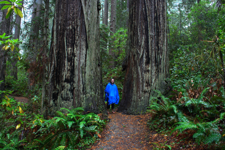
Pic on the right shows Anna on the trail walking between two massive trunks. I'm glad we left Yosemite early, so that we could see this place; originally we had planned to spend at least three days at Yosemite and then head south to Kings Canyon and Sequoia National Parks, but since we got pissed-off at Yosemite and left early, we decided to make the long drive north and west to see Lassen Volcanic National Park and Redwood National/State Park. Despite the horrible upper-back pain I consider this particular day to be one of three favorites on this trip. |
 |
|
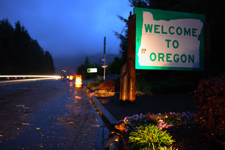
We drove north through the park after walking the Lady Bird Johnson Grove trail; we drove along the Newton B. Drury Scenic Parkway, which was absolutely incredible! I don't have any pics from that section of road, but just imagine driving through a thick forrest of the tallest trees in the world with clouds, fog, rain, and bits of needles falling from the canopy due to the increasing winds associated with the powerfull mid-latitude cyclone slamming the coast! We were cold and wet, so we didn't stop until we reached the Oregon/California border, where I jumped out and took a picture of the Oregon sign and we drove a half mile into Oregon and made a U-turn back into California. We ate at a nice seafood resturant in Crescent City, CA and I had made up my mind to drive all night along Route 101 over the Golden Gate Bridge into San Francisco and the turn east toward Sequoia/Kings Canyon National Parks. I didn't want to get a hotel, it was rainy and there were landslides everywhere and I knew it would only get worse the next day, and my back was in pain, so sleeping would only let it get really tight and be in worse pain in the morning. So, I beefed up on Mountain Dew and Coffee drinks and drove all night long through the moderate/heavy rain and high winds along Route 101. |
 |
|
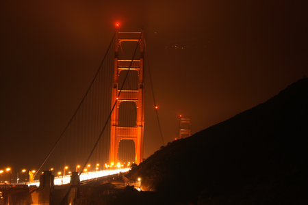
The pic on the right was taken at ~4-5 am on the north side of the Golden Gate Bridge; the pic shows the Golden Gate Bridge shrouded in fog/clouds/rain...perfect! We drove over this historic landmark shortly after this picture was taken. We continued on our way south through San Fran and San Jose, and turned east back to the big Sierra Nevada Mountains. |
 |
|
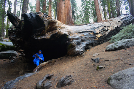
We stopped at a fruit stand in the Valley east of Fresno and bought some amazing peaches, dried bananas, and grapes for breakfast. We then drove east towards Kings Canyon National Park. We first stopped at Grant Grove to see the General Grant tree in Kings Canyon National Park. The pic on the right shows Anna standing inside a downed Giant Sequoia at Grant Grove; this thing was huge! It looks like she is in a cave! She is pretty far away from the camera when I took this pic and yet she was still far from the other end of the tree, while I was actually in the tree myself with the tripod and camera! |
 |
|
The pic on the right shows Anna at the entrance to the root section/bottom of the massive tree from the pic above. She is also holding a huge pine cone, which I believe is not from a giant sequoia tree, but from one of the other species of evergreen trees in the huge oldgrowth grove. |
 |
|
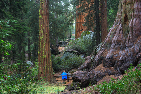
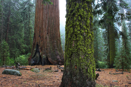
The pic on the right shows Anna (blue poncho) on a trail with massive giant sequoias all around her; the one to her left would actually be considered small or young compared to the massive trunk seen on the small hill behind her and the small section of trunk on the right side of the pic, which happens to be part of the General Grant tree, which is the third largest tree (per volume) in the world. |
 |
|
The pic on the right is a shot of some trees in the Grant grove of Giant Sequoias. |
 |
|
Pic on the right is another shot of trees in Grant Grove. |
 |
|
Shot on the right shows me (red raincoat) inside a fallen hollow giant sequoia, different tree from previous pics above, which shows the immense size of these ancient trees. |
 |
|
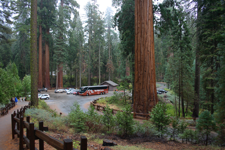
Pic on the right is looking at the parking lot of Grant Grove to show the incredible size of the trees in this oldgrowth forrest compared to the cars and even a bus in the parking lot. |
 |
|
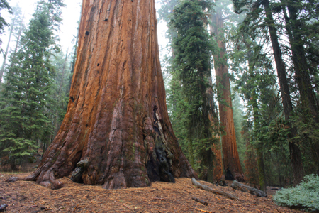
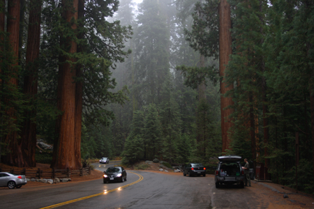
We continued on our way and decided to skip the main section of Kings Canyon and go straight into Sequoia National Park and see the General Sherman The pic on the right shows some massive Giant Sequoias along the main road in Sequoia National Park; look how small the cars are compared to these trees. |
 |
|
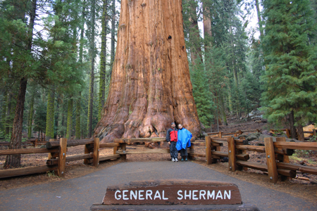
Finally, a boyhood dream had come true, I got to see the General Sherman Tree in person! This is the largest tree and organism in the world! The pic on the right show Anna and I posing in front of General Sherman. |
 |
|
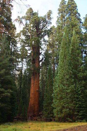
The pic on the right show General Sherman (massive tree in the middle) with a group of people at the base to show the incredible size of this ancient tree. |
 |
|
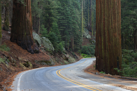
Pic
on the right shows the road cutting between two massive Giant Sequoia
trees; each of thesed two tree trunks were much wider than a single
lane on this road.
|
 |
|
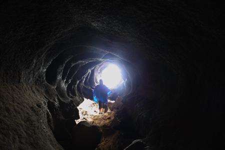
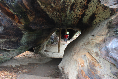
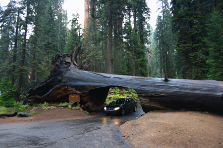
Pic on the right shows my car driving under a fallen Giant Sequoia that had a tunnel carved for cars. We decided to see a few more tourist parts of the park and then continue on our way. |
 |
|
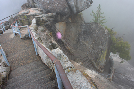
The day was coming to an end, but we tried to get a peak of the surrounding area by climbing up a very long staircase cut/built along a ridge leading up to Moro Rock. The pic on the right shows Anna (pink blur on the staircase below due to slow shutter speed) climbing a very small section of the very long staircase leading up Moro Rock. Apparently there is an incredible view of Sequoia National Park from Moro Rock, but we were socked in by clouds, so we only saw small breaks and pieces of a view from the top. The climb up the stairs was fun! |
 |
|
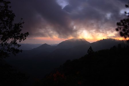
It was getting cold and we decided to leave Sequoia National Park since the weather would still be wet and cloudy the next day, so I continued on no sleep from the night before and drove us south and out of the park. On the way down we saw the best sunset of the trip looking west over the valley toward Visalia. The pic on the right shows this amazing sunset, at least the best I could capture, with the lights of Visalia in the valley below and the clouds streaming over the foothills of the Sierra Nevada Mountains. |
 |
|
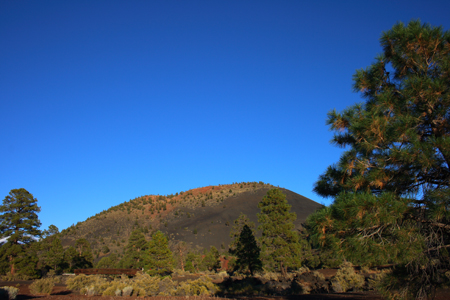
I drove late into the night and finally had to stop at a rest area near Boron, CA. By the way, this was the most 'ghetto' rest area I had ever seen! There was graffiti all over the inside and outside of the buildings and the inside of the bathrooms were heavily vandalized! I'm assuming gangs did most the damage... I didn't realize until I looked at the map that we were so close to Los Angeles, in fact we were due north of LA, but I really didn't have any urge to go there, so we woke the next morning and continued east across the dry and desolate Mojave Desert. We crossed into Arizona and were soon able to spot a snow-capped Humphrey's Peak in the distance. The cooler mid-level temps and precip from the strong trough had brought snow to the over the past few days. We decided to stop at Sunset Crater National Monument east of Humphrey's Peak and we watched the sunset. The pic on the right shows sunset crater volcano, which errupted about a thousand years ago, which is pretty recent in geologic time! This is a cinder cone volcano as opposed to the massive stratoform monster of Humphrey's Peak to its west. We stopped at local Brewery in Flagstaff and had some hometown beers and got our third and final motel of the trip. |
 |
Home
| Storm Store | Photo
Gallery | Message
Board | Storm Chases | Latest
News
Stock Footage | About
| Contact | Editorial
| Weather Links
Copyright 2004 Stormgasm.com. All rights reserved.